Town Resources, Public Access and Bremen Trails
Bremen Public Library
204 Waldoboro Road
Bremen, Maine 04551
Tel. (207) 529-5572
Tues., Wed., & Fri. 10 am to 3 pm
Thur. – 10 am to 7 pm
Sat. – 10 am to 12 noon
Email: bremenmainelibrary@gmail.com
Website: www.bremenlibrary.org
Nobleboro Transfer Station (Access to Bremen Residents)
25 Transfer Station Road
Nobleboro, ME 04555
Tel. (207) 563-1610
Hours:
| Monday | Closed |
| Tuesday | 8:00 am – 4:00 pm* |
| Wednesday | 8:00 am – 4:00 pm* |
| Thursday | 8:00 am – 4:00 pm* |
| Friday | 8:00 am – 4:00 pm* |
| Saturday | 8:00 am – 4:00 pm* |
| Sunday | Closed |
*NOTE: Nobleboro Transfer Station gates are closed at 3:50 p.m. for that day’s business.
AOS 93/ Central Lincoln County School System
767 Main Street
Damariscotta, ME 04543
Office (207) 563-3044
Fax (207) 563-8276
Website: http://www.aos93.org
Miles Memorial Hospital
35 Hospital Entrance Damariscotta, ME 04543
Tel. (207) 563-1234
Website: http://www.mileshealthcare.org
Lincoln County Sheriff’s Department
Lincoln County Sheriff : Todd B. Brackett
42 Bath Rd., P.O. Box 611, Wiscasset, ME 04578
Emergency #: 9-1-1
Non-Emergency Phone: 882-7332, 549-7072, 563-3200, 832-4000
fax: 207-882-9872
Website: https://www.lincolnso.me
124 Friendship Road
PO Box 692
Waldoboro, ME 04572
Phone 207-520-5100
Email: waldoborofoodpantry@outlook.com
Hours of Operation: 1st and 3rd Tuesday of each month
12 noon to 3 p.m. (Drive-through distribution only)
Waldoboro Free Clothing Closet
124 Friendship Road at Medomak House (site of the Food Pantry)
Hours of Operation: Every Friday and Saturday 10 a.m. to 2 p.m.
(See flyer for more information)
Waldoboro Free Clothing Closet Flyer Print June 2021
Public Access Points
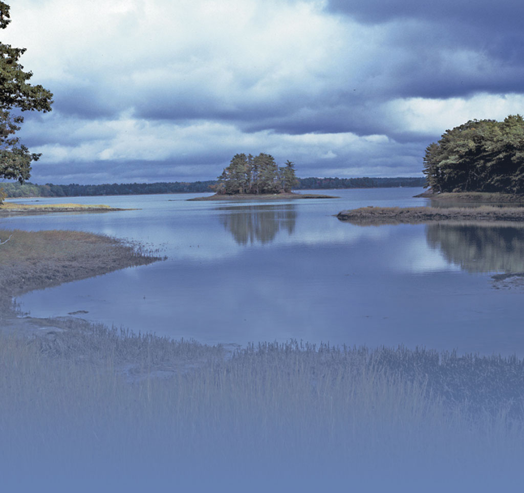
Bremen Town Landing-Main Town Dock and Parking Facility – Located at the end of Town Landing Road directly off Medomak Road. Ample parking but no boat launching availability. Could carry a canoe or kayak to the end of the dock or with some difficulty launch from shore. No facilities.
Bremen Long Island-Mid Island Town Landing – Located directly east of the Bremen Town Landing on Town Landing Road off Medomak Road.
Bremen Long Island-Southern End Landing – Located on very southern tip of the island but inside the sheltered cove. The road on the island connects this landing to the Bremen Long Island Mid Island Landing. A gravel pad is at the southern end for launching.
Clam Island – Located almost directly across from the Bremen Town Landing and clearly visible. This island was deeded to the Town by the Noyce Family. There is a loop trail through fields of ferns and woods, approximately 1/2 mile, that can be accessed at both the southern and northern ends of the island. The trial continues to the northern end of the island to a stone beach. Access by small boats only. There is no designated landing area, but a stone beach at the southern end, a mud bottom cove on the eastern side (at low tide all mud) and another stone beach on the northwestern end are suitable depending on the wind direction. Marked by orange triangles. Day use only. No fires.
Creek Road Landing – At the end of Creek Road off the Medomak Road. There is a parking spot on the left for 2 cars. The access goes from this area down to the water by a rough path approximately 100 feet. Tidal entry.
Hay Conservation and Recreation Area – Located on Route 32 just north of Turner Road. Small parking lot on top of property with beautiful view of the water. Foot trail and gravel road down to the water approximately 1/4 mile. Tidal entry. Hay Conservation and Recreation Area, Bremen – Maine by Foot
Origin of the Hay Property
Heath Road Bridge – Located midway on Heath Road. There is parking for one car. View of saltwater marsh and lovely walk on quiet road.
Hog Island – Hog Island is a National Audubon property located south of Oar Island across from the private Audubon dock at the end of Keene Neck Road. Access by boat only by the southern-most float on the west side of the island. Todd Wildlife Sanctuary | Hog Island Audubon Camp
Berger Preserve – This is a 180-acre preserve on Bremen Long Island. Access is by small boat only at any tide. Look for the orange triangle that marks the western trailhead. Berger Preserve — Midcoast Conservancy
Keene Neck Road Greenland Cove/Mill Pond Access – Located about 1/8 mile down Keene Neck Road on the right. It is not marked, but one will notice a one- to two-car parking area next to a natural entry to the tidal Mill Pond.
Storer Road Landing – Located at the end of Storer Road, this area is a tidal access ramp into the Bugtussle and Broad Cove areas. It is often used by local fishermen.
McCurdy Islands Preserve – Located in McCurdy Pond at the causeway on Turner Road. There are no trails on the 11.5-acre preserve, so best to enjoy by canoe or kayak. The best place to launch is on the far end of the causeway on the right coming from Biscay Road. There is a small pullout on the right and a two-car parking area after the causeway on the left. The island is a loon nesting site and landing on the island is discouraged to protect its wild state and wildlife. The preserve was donated to Pemaquid Watershed Association, now Coastal Rivers Conservation Trust, in 2017 by the estate of Anne Frohock.
Pemaquid Pond Preserve – On Turner Road after the causeway heading east. Steward of the property is Coastal Rivers Conservation Trust. For more information go to Pemaquid Pond Preserve – Coastal Rivers Conservation Trust.
Pemaquid Pond Trail Guide
Walking Trails and other Properties
Town Center Property for Sledding – Located behind the Town Office on Route 32 (208 Waldoboro Road). There is a gentle hill for smaller children.
Town Center Ball Field – Located behind the Town Office on Route 32 (208 Waldoboro Road). This is basically a mowed field.
Bremen Town Forest (also called the Hilton-O’Connor Trail) – This forest and trail is located on Route 32 just north of the Bremen Fire Station.
A Walk in the Woods – Bremen Style
Hillside Trail – Located on Route 32 above the Hillside Cemetery. Drive to the top of the cemetery to park. The trail is behind the cemetery and is on an old logging road approximately 1 mile long. The trail has recently been acquired (in 2020) and is not well-maintained. It ends in a wet/boggy area where most decide to turn around.
Audubon Mainland Trails – A 30-acre parcel located at the end of Keene Neck Road. Todd Wildlife Sanctuary | Hog Island Audubon Camp
Coastal Rivers Conservation Trust – Please visit this website for more information about CRCT trails. coastalrivers.org
